Abstract
This document introduces a generic data model developed at ISRIC implementing the ISO 28258 standard. Furthermore, the data model captures the extensive code-lists gathered in the GloSIS web ontology as thesauri. This data model is intended as a template to be specialised in particular projects or use cases. Soils4Africa was the first of such projects. Details are given on how model classes and associations were translated into tables and relations, together with maintenance and development guidelines.
Copyright
Copyright (C) 2022-2023 ISRIC - World Soil Information
Permission is hereby granted, free of charge, to any person obtaining a copy of this software and associated documentation files (the “Software”), to deal in the Software without restriction, including without limitation the rights to use, copy, modify, merge, publish, distribute, sublicense, and/or sell copies of the Software, and to permit persons to whom the Software is furnished to do so, subject to the following conditions:
The above copyright notice and this permission notice shall be included in all copies or substantial portions of the Software.
THE SOFTWARE IS PROVIDED “AS IS”, WITHOUT WARRANTY OF ANY KIND, EXPRESS OR IMPLIED, INCLUDING BUT NOT LIMITED TO THE WARRANTIES OF MERCHANTABILITY, FITNESS FOR A PARTICULAR PURPOSE AND NONINFRINGEMENT. IN NO EVENT SHALL THE AUTHORS OR COPYRIGHT HOLDERS BE LIABLE FOR ANY CLAIM, DAMAGES OR OTHER LIABILITY, WHETHER IN AN ACTION OF CONTRACT, TORT OR OTHERWISE, ARISING FROM, OUT OF OR IN CONNECTION WITH THE SOFTWARE OR THE USE OR OTHER DEALINGS IN THE SOFTWARE.
You should have received a copy of the MIT Licence along with this program. If not, see <https://mit-license.org/>.
0.0.1 Recommended citation
de Sousa, L. M., Calisto, L., van Genuchten P., Turdukulov, U., Kempen, B., 2023. Data model for the ISO 28258 domain model. ISRIC World Soil Information. Available at: https://iso28258.isric.org/
1 Introduction
1.1 Motivation
In late 2021 a requirement emerged in the Soils4Africa project for a relational database model directed at the storage of soil properties observations. At first, the data model of the World Soil Information Service (WoSIS) was considered. However, this path presented an insurmountable challenge from the onset, as the WoSIS data model was developed ad hoc, unrelated to the state-of-the-art in soil ontology. In addition, this data model does not always follows best practices in SQL and relational database modelling. Among the issues with the WoSIS data model, the following can be highlighted:
- absence of thesauri or other mechanisms for controlled content;
- data type mismatches, e.g. numerical values stored in text fields;
- functional dependencies (marked with the concept of “attribute”);
- unclear semantics (in the data model and documentation).
While not the most severe issue, the lack of controlled thesauri renders the WoSIS data model nearly unusable outside the context for which it was developed. The other issues carry risks for maintenance and data accuracy that can easily become too expensive to address.
1.2 The option for an international standard
A second path was thus considered, developing a more general data model following the state-of-the-art in soil ontology. Several models have been proposed as basis for the exchange of soil data that offer a starting point for a data model. No thorough comparison was undertaken between the different options, the domain model proposed in the ISO 28258 standard was adopted outright for a first prototype. ISO 28258 is the only truly international standard directed at soil data exchange, with the alternatives being primarily regional in nature (e.g. INSPIRE, ANZSoilML). Soils4Africa taking place in a different continent, and with the goal of a generic data model in mind, the international model was the default choice. Further details on how these different models compare are offered in Section 2.2.
The ISO 28258 domain model provides a “shell” architecture meant to be specialised for particular contexts. Initial data model prototyping proved that to be the case. Moreover, the parenthood of ISO 28258 to the GloSIS web ontology also facilitated the use of controlled content referenceable on the web.
1.3 Structure
This document is structured as follows. Section 2 briefly presents the ISO 28258 standard and the domain model it proposes, also comparing with other relevant models in soil ontology. The features of interest included in the data model are introduced next, in Section 3, after which the observations and measurements assets are presented in Section 4. Section 5 details the procedures employed to populate the thesauri and their intended use. Meta-data is addressed in Section 6. Some relevant operational aspects of the data model are discussed in Section 7. The document concludes by pointing directions for future work in Section 8.
1.4 Format
This document is encoded with the Markdown language, meant to be
compiled with the Pandoc system 1. It is maintained within
the iso28258 repository itself 2.
1.5 Glossary
- Data model: a logical structure for the storage of
a data (usually in a digital system). In most cases a data model
implements the informational aspect of a domain model. In this document
relations in a data model are represented with lower case e.g.,
element. - Domain Model: an abstraction synthesising the
information (and in some cases behaviour) of a specific domain. Often
represented with a visual language like UML. A domain model can also be
referred as “ontology”. In this document classes or concepts in a domain
model are represented with capital characters,
e.g.
SoilElement. - Feature of Interest: a class in the Observations and Measurements domain model representing the subject of an observation or measurement. I.e. what is meant to be observed.
- Observations and Measurements (O&M): a standard sanctioned by ISO and the OGC providing a domain model for information captured with human instruments and methods on natural phenomena.
- ontology: an information abstraction resulting from the application of Ontology principles to the information/computer science domain. Expressed with lower case “o”, an ontology is a domain model, usually not including behavioural aspects.
- Semantic Web: network of standard and specifications issue by the OGC for the digital exchange of data over the internet. It includes the Unified Resource Identifier (URI), the Resource Description Framework (RDF), the Web Ontology Language (OWL), the SPARQL query language and much more.
- Thesaurus: a controlled set of terms that may be associated to a specific class property or table column. E.g. the set (red, green, blue) would be a thesaurus for the colour property. The concept of thesaurus is close to those of code-lists and vocabulary.
2 The ISO 28258 domain model
2.1 Overview
The international standard “Soil quality - Digital exchange of soil-related data” (ISO number 28258) (“Soil quality – Digital exchange of soil-related data” 2013) is the result of a joint effort by the ISO technical committee “Soil quality” and the technical committee “Soil characterisation” of the European Committee for Standardisation (CEN). Recognising a growing need to combine soil data with other types of data - especially environmental - these committees set out to produce a general framework for the unambiguous recording and exchange of soil data, consistent with other international standards and independent of particular software systems.
The ISO 28258 standard was from the onset developed to target an XML based implementation. Its goal was not necessarily to attain a common understanding of the domain, rather to design a digital soil data exchange infrastructure. Therefore the accompanying UML domain model on which the XML exchange schema is rooted was merely a means to an end. Also recognising the relevance of spatial positioning in soil data, the standard adopted the Geography Markup Language (GML) as a geo-spatial extension to the XML encoding.
Even though not necessarily focused on a domain model, ISO 28258 captures a relatively wide range of concepts from soil surveying and physio-chemical analysis. The domain model is a direct application of the meta-model proposed in the Observations and Measurements (O&M) standard (“Geographic information – Observations and measurements” 2011) to the soil domain. It aims to support both analytical and descriptive results.
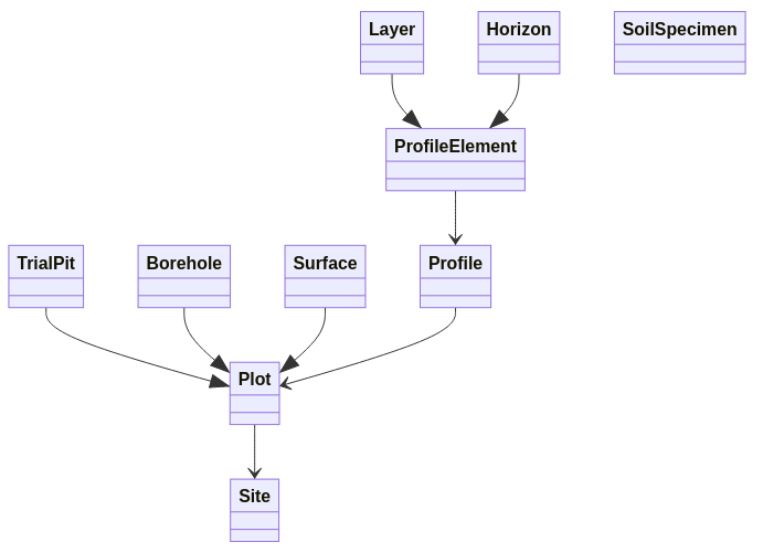
ISO 28258 identifies the following features of interest:
Site- representing the surrounding environment of a soil investigation, the subject of observations such as terrain or land use.Plot- the location or spatial feature where a soil investigation is conducted, usually leading to a soil profile description and/or to the collection of soil material for physio-chemical analysis.Plotis further specialised intoSurface,TrialPitandBorehole.Profile- an ordered set of soil horizons or layers comprising the soil pedon at a specific spatial location. The object of soil classification.ProfileElement- an element of a soil profile, characterised by an upper and lower depth. Specialised intoHorizon- a pedo-genetically homogeneous segment of the soil profile - andLayer- an arbitrary and heterogeneous segment of the soil profile.SoilSpecimen- an homogenised sample of soil material collected at a specific soil depth. Usually meant for physio-chemical analysis.
Figure 1 presents a simplified diagram of the ISO 28258 domain model showing the relevant relations between features of interest.
Meant as an asset for global use, ISO 28258 did not went into further specialisation. It does not propose attribute catalogues, vocabularies or code-lists of any kind, remaining open to the different soil description and classification systems used around the world. Although specifying a class for the traditional concept of “mapping soil unit” used in vector based soil mapping, the standard does not actually support the raster data paradigm. ISO 28258 was conceived as an empty container, to be subject of further specialisation for the actual encoding of soil data (possibly at regional or national scale). However, the standard has so far never been applied in this context it was designed for. The combination of a XML/GML approach (for which off-the-shelf tools remain scant) with the lack of code-lists possibly made the outright adoption of this standard too abstract for soil data providers.
2.2 Relation with other soil ontologies
The ISO 28258 domain model is semantically rooted in O&M (see Section 4 for details), re-using UML stereotypes from that standard throughout. This architecture automatically aligns ISO 28258 with other standards from ISO and the OGC, such as Sampling Features. Moreover, it also provides alignment with other soil ontologies that follow a similar philosophy.
2.2.1 INSPIRE Soil Theme
Perhaps the most relevant among the domain models related to ISO
28258 is the Soil Theme domain model published by the European
Commission in the context of the INSPIRE directive (Soil 2013). The core
of these two models, concerning the abstraction of observations and
measurements is by and large the same, with the concept of
Observation expressed as a triple: Property,
Procedure and Unit. As for the features of
interest there are differences mainly in how the spatial surrounding of
a soil investigation is abstracted. The concepts of Plot
and Site are also present in INSPIRE but in a leaner way,
without the specialisations found in ISO 28258. INSPIRE further adds the
concept of SoilBody, a wider spatial area in which various
soil investigations are conducted. And the concepts of
RectifiedGridCoverage and
ReferenceableGridCoverage provide a back-bone for gridded
data.
2.2.2 OGC SoilIE
In 2016 the OGC hosted an initiative named Soil Interoperability Experiment (SoilIE) (“OGC Soil Data Interoperability Experiment” 2016) with similar goals to those of ISO 28258. Also focused on data exchange, SoilIE would go into far more detail concerning features of interest. The resulting domain model is sub-divided into four sub-models, each addressing a specific aspect of soil information: (i) soil classification; (ii) soil profile description; (iii) sampling and field/laboratory observations; and (iv) sensor-based monitoring of dynamic soil properties. Left out of the experiment were soil mapping and landscape/land-use characterisation.
The SoilIE domain model yields familiar concepts such as
Site, Plot, Soil,
Layer, Horizon or Sample. But
these are complemented by many other classes, in what is a far broader
set of features of interest, with more intricate relationships. However,
to what observations and measures is concerned, the same patterns
proposed in the O&M standard are applied in this domain model
too.
2.2.3 GloSIS
The GloSIS web ontology is essentially a translation of the ISO 28258 domain model to the Semantic Web, employing the Ontology Web Language (OWL). While semantically it is the same model, GloSIS introduces large sets of ready to use code-lists, including:
Descriptive properties values (transposed from the FAO Guidelines of Soil Description (Jahn et al. 2006)).
Physio-chemical properties (for Layer, Horizon, Plot and Profile).
Procedures associated with physio-chemical properties (re-used from the Africa Soil Profiles project (Leenaars, Van Oostrum, and Ruiperez Gonzalez 2014)).
By adopting the Semantic Web paradigm, this ontology automatically expresses all its content with Universal Resource Identifiers (URIs), than can easily be rendered dereferencable with a service such as W3ID (Group 2022). The GloSIS web ontology has in this way become one of the most extensive resources on soil ontology on the web.
2.3 Issues identified
During the course of this work various issues were identified with the ISO domain model that required addressing in the adaptation to the Soils4Africa project. In particular:
The
SurfaceandSiteconcepts revealed too similar and difficult to distinguish by soil scientists. Although yielding slightly different properties, the domain model is not fully clear. Moreover, a polygon type of spatial feature is expected to have a one-to-one relation with aProfile.The
SoilSpecimenconcept is defined with a single depth property, whereas in soil surveying a sample collected in the field is always reported with two depths (upper and lower boundaries). A specimen (or sample) is regarded as a tangible segment of the soil profile whose material is homogenised.SoilSpecimenandLayerappear also as too similar concepts. Both report to an arbitrary segment or stratum of the soil profile, in most cases unrelated to pedo-genetic horizon boundaries. Moreover, soil properties assessed in laboratories from soil specimens are often reported in reference to a soil layer by data providers. The depth issue noted above blurs the distinction between the two concepts even further.
3 Features of Interest
3.1 General
The ISO 28258 domain model was translated into a relational data model in the most seamless way possible. Whenever practical, classes and their attributes were translated directly into relations and attributes (or tables and columns). Generalisations were dealt with case-by-case, applying the child relations rules, i.e. creating individual entities for the children only if they bear diverse relations with other classes. This section reviews the entities and relationships implementing the features of interest (FoIs) and related assets.
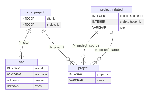
3.2 Project and Site
The first concept to introduce is that of Project, a
general placeholder providing the context of the data collection
activity. The ISO domain model considers this a prerequisite for the
proper use or reuse of these data. Within a project one or more soil
investigations take place. It can be a soil sampling campaign, a regular
soil survey, or some other organised process of soil data collection.
The table project contains a single field for the project
name, exposing the open nature of this concept (Figure 2).
A project can be related to one or more other projects. For instance,
if a certain field campaign occurs at regular time intervals, the user
might wish to record each as a single project, but related to others
undertaken at a different time. Hierarchical relations can also be
recorded this way, expressing a certain project as sub-project of
another one. The table project_related provides the
role field in which the user may express the nature of the
relationship.
A soil investigation takes place within a certain spatial area or
extent: the Site. A site is not a spatial feature of
interest, but provides the link between the spatial features of interest
(Plot) to the Project. It can be expressed
either as a location (point) or spatial extent (polygon). The fields
position and extent in the site
table provide for this information, being that only one may be non empty
for each record.
3.3 Spatial Features
All features of interest in the ISO 28258 model relate to a site, directly or indirectly. It is not possible to express information without previously defining the spatial extent within which the soil investigation took place. A single site may host more than one investigation, thus assumed to have an heterogeneous soil composition.
The soil investigation itself is conducted in a precise spatial
location - the Plot - the first spatial feature of
interest. The Plot can be of three different kinds:
Surface, Pit or Borehole. The
Surface corresponds spatially to a polygonal feature, a
spatial extent within which the character of the soil tends to be
homogeneous. Surface can express soil investigations
recorded with high positional inaccuracy. The model also defines a
hierarchical relation between surfaces.
Both the Borehole and the Pit correspond to
point type spatial features, translating locations recorded with good
positional accuracy. A borehole represents soil investigations conducted
with an auger or similar boring instrument, whereas a pit indicates a
soil excavation activity. In practice, both Borehole and
Pit yield the same properties and relations,
undistinguishable as data structures.
The Plot was thus modelled with two tables: one for the
Surface and another - named plot - for
Borehole and Pit. Both of these have a
mandatory relation to a site. The plot table has a
Point type column as spatial feature and
surface a Polygon type column. As Figure 3
shows, the plot table contains a different set of
columns.
The plot and surface tables provide the
spatial hook on which to record a soil Profile (a vertical
sequence of soil horizons). The resulting profile table is
rather simple, yielding a code column and two foreign keys,
one for plot and another for surface. A
CHECK constraint forces one, and only one of these two
foreign keys to be used simultaneously.
Note the nature of the relation between Plot and
Profile being one-to-many. Meaning that more than one
profile can be associated with the same plot (of whatever kind). This
kind of association is not meant to related profiles collected at
different points in time to a same plot. In such case the two profiles
would be in different projects and would thus relate to different
plots.
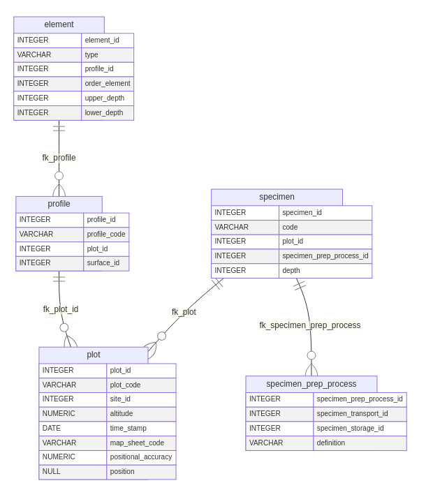
3.4 Other Features of Interest
There are three further features that do not have spatial expression
but still are passible or measurement. Two are the profile elements:
Layer and Horizon, the third being the
SoilSpecimen.
Layer and Horizon present a similar nature:
a section of the soil profile starting and ending at defined depths.
Each instance is recorded in a particular order, re-creating the full
soil profile. Semantically, Layer and Horizon
differ in their composition, the latter is homogeneous, the former
heterogeneous. An horizon is identified by field observation, through
sharp transitions of colour, composition or texture. Layer depths are
usually pre-determined prior to field work. However, this difference
does not translate into different properties or relations in the data
model. Therefore, both Layer and Horizon are
captured in a single table: element. The field
type provides the means to distinguish between layer or
horizon, if needed be. Figure 4 provides an overview of these
relations.
The simultaneous inclusion of the properties
upper_depth, lower_depth and
order rapports important redundancies that are worth
noting. The depth fields are recorded as positive integers representing
centimetres from the surface, increasing downwards. The data model
forces upper_depth to be lower than
lower_depth. However the model cannot prevent overlapping
profile elements from being recorded. Likewise, it cannot guarantee
consistency between order and the depth columns. These
redundancies are translated from the domain model “as is” since they
portray common practice in soil survey. For these issues to be fully
addressed a business rules layer is necessary (e.g. with database stored
procedures).
The concept of SoilSpecimen in ISO 28258 is derived from
the ISO 10381 standard for Soil Sampling (Standardization Organization) 2002). In
essence it is a portion of soil matter (implicitly assumed as
homogeneous) collected at a certain depth, meant to be transported to a
storage facility where it may be further prepared and analysed with
different methods. It does not appear directly associated to any
specific feature in the ISO 28258 domain model, but its parent structure
in ISO 10381 indicates possible associations with spatial features that
may function as sampling platforms. The WoSIS database includes a
similar concept, sample that appears associated with a site
or plot. The same approach was thus taken in the ISO 28258 data model
with a one-to-many association between plot and
specimen. An additional table,
specimen_prep_process, provides essential attributes to
record how a sample is transported and stored.
4 Observations & Measurements
4.1 Main concepts
O&M (“Geographic information – Observations and
measurements” 2011) presents a general framework to
encode measurements of natural phenomena of any kind. The concept of
Observation is at its core, in essence a triplet of three
other concepts:
Property: an individual characteristic of a feature of interest. E.g. sand fraction in a profile element.Procedure: an action performed on a feature of interest (or sampling feature) in order to measure a property. E.g. sieving with 2 mm and 0.05 mm grades.Unit of measure: defines the magnitude of a measurement executed with a particular procedure on a property. E.g. per mille.
The Result class provides the actual placeholder for
measurement results. It refers to a feature of interest and an
observation and provides a matching value. The nature of this value is
left completely open, it can be of any kind.
4.2 Physio-chemical Observations
Observations of physio-chemical properties of the soil provide a full introduction to the implementation of O&M in a relational database. These observations produce numerical results and refer to relatively well known procedures of wet chemistry and related soil specimen treatment.
The model proposed by O&M can be transposed to a relational
structure nearly literally, however, there is an important choice to
make regarding the nature of the relevant feature of interest. Since
Result ought to refer to a feature, it must be translated
into as many relational tables as many different features of interest
exist. Therefore corresponding result tables are necessary for
surface, plot, profile,
element and specimen.
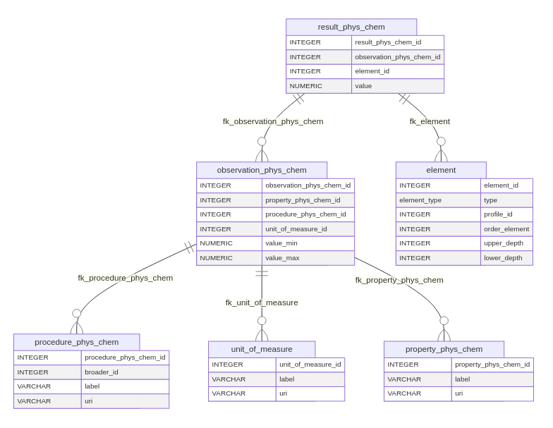
Considering physio-chemical observations, in practice only
Element and Specimen yield observations of
this nature, with numerical values as result. For element
the observation tables include the suffix _phys_chem
whereas for specimen it is numerical_specimen. If further
features of interest come to require numerical observations this suffix
system must be harmonised.
The observation table is in essence a ternary
association, with foreign keys to property,
procedure and results. In addition the columns
value_min and value_max provide an interval of
admissible values to guarantee data consistency (e.g. per mille). Figure
5 provides an overview of the observation assets for the
element entity.
The tables for property, procedure and
results are thesauri, not meant for direct modification by
users. They provide the controlled content in this segment of the data
model. In all three tables the natural columns are a human readable
label and an uri to an entry in an on-line
controlled vocabulary. This configuration is specifically designed to
align the data model with the GloSIS web ontology (details in Section
5), but it also facilitates referencing other on-line sources of
controlled content. The procedure table includes an
additional foreign key to itself, for the encoding of hierarchical
procedures, with different levels of detail.
Closing this segment of the data model is the result
table. It refers both to an observation and a feature of
interest (element for result_phys_chem and
specimen for result_numeric_specimen). A
numeric column named value hosts the actual measurement. To
each numerical result table a trigger is associated that on insertion or
update verifies the value against the value_min and
value_max columns in the associated observation. In case it
is outside the admissible interval, an exception is raised and the value
remains unchanged.
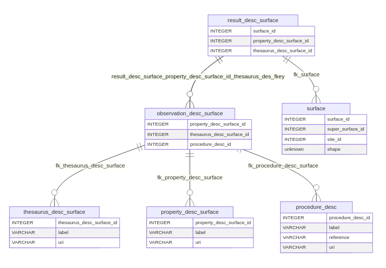
4.3 Descriptive Observations
Various of the soil properties assessed during field work provide qualitative or descriptive results from direct observation, dispensing laboratory analysis. Examples are water drainage or soil classification. Results from these observations are thus textual in nature, ideally in reference to controlled content sources.
Compared to numerical observations, the main difference in the translation of the O&M pattern to a relational model for descriptive observations is in the nature of the result, it becomes a reference (foreign key) to a thesaurus. A thesaurus provides a list of controlled terms or items, that as a rule may not be modified by system users.
All features of interest can be subject to descriptive observations.
Therefore the O&M pattern is replicated to each one, with a suffix
to the table making the distinction. An exception was opened to the
procedures thesaurus. In this case a procedure is a publication (field
manual, soil description guidelines, etc) of which few are expected and
should apply equally to different features of interest. Figure 6
presents the tables for the descriptive observations related to
Surface, thus yielding the suffix _surface.
Similar tables exist for plot, profile and
element.
A property_desc table provides the thesaurus for
properties, just like in the numerical observations case.
thesaurus_desc provides the additional controlled lists of
descriptive terms to associate with properties.
procedure_desc hosts then the thesaurus of publications.
The observation_desc table relates these previous concepts
in a ternary relationship as before.
The result_desc table is simply composed by two
references, one to the feature of interest and another to the
observation. The latter is actually a composed foreign key with the
primary keys of the property and the respective item in the descriptive
thesaurus. A joint unique constraint is applied on the foreign keys to
the feature of interest and the property, guaranteeing that only one
result is recorded for each property of each feature of interest.
5 Thesauri
5.1 GloSIS code-lists
One of the advancements GloSIS brings to soil ontology is the introduction of comprehensive and structured code-lists. Making the best use of the Semantic Web, these code-lists are structured according the Simple Knowledge Ontology System (SKOS) (Miles and Bechhofer 2009) with each item fully de-referenceable. SKOS also makes these code-lists easily extendable.
GloSIS currently comprises code-lists for three cases:
Descriptive property values: as digitised from the FAO Guidelines for Soil Description during the consultancy work for Pillar 5 of GSP (Řezník and Schleidt 2020). Some 830 codes are currently found in these code-lists.
Physio-chemical properties: in accordance to the Tier1/Tier2 inventory gathered within the Pillar 4 of GSP (Batjes, Kempen, and Egmond 2019), comprising 80 individual items.
Physio-chemical procedures: adapted from the large catalogue assembled within the Africa Soil Profiles project (AfSP) (Leenaars, Van Oostrum, and Ruiperez Gonzalez 2014), currently totalling over 200 individuals.
Beyond these code-lists, the GloSIS ontology also embodies a large
collection of descriptive soil properties. However, these are not
modelled as code-lists, but rather as direct instances of the
Property class from the SOSA ontology. Over 160 such
properties currently exist in the ontology, across all features of
interest.
These collections of controlled content provide a wealth of information form which to start a soil information system or an ad hoc database as the one described in this document. The GloSIS ontology is currently hosted at the W3ID service set-up by the W3C 3, guaranteeing an important level of resilience. Moreover, GloSIS remains in active development with accompanying tools that will facilitate the involvement of soil scientists.
SoilIE attempted a similar approach to controlled content, also producing code-lists with dereferenceble items. However, these are no longer on-line so it is not possible to compare their implementation.
5.2 SPARQL transformations
A series of transformations were created to obtain relational
database records from the GloSIS ontology. They are coded as SPARQL
queries and stored in the sparql folder of the code
repository 4. Each of these queries obtain as
output a set of SQL INSERT instructions that for each
code-list item create a counterpart record in the corresponding
thesaurus in the database.
The query in Listing 1 populates the thesaurus for descriptive
properties associated with the GL_Profile class in GloSIS
(Profile in ISO 28258). First, it identifies the relevant
observations, those whose feature of interest is the
Gl_Profile class (with the
sosa:hasFeatureOfInterest predicate). Secondly, it
identifies the associated properties with the
sosa:observedProperty element. It then identifies the
associated result and corresponding values code-list
(sosa:hasResult). Using the BIND function the
resulting SQL INSERT instruction is produced as a string.
Similar SPARQL queries were developed for all other features of
interest.
Listing 1: SPARQL query transforming descriptive observations for the `GL_Profile` class into SQL `INSERT` instructions.
PREFIX rdfs:  <http://www.w3.org/2000/01/rdf-schema#>
PREFIX owl:   <http://www.w3.org/2002/07/owl#>
PREFIX sosa:  <http://www.w3.org/ns/sosa/>
PREFIX skos:  <http://www.w3.org/2004/02/skos/core#>
PREFIX glosis_su:  <http://w3id.org/glosis/model/v1.0.0/profile#>

SELECT ?query
WHERE {
    ?obs rdfs:subClassOf sosa:Observation .
    ?obs rdfs:subClassOf ?rest_f .
    ?obs rdfs:subClassOf ?rest_p .
    ?obs rdfs:subClassOf ?rest_r .
    ?rest_f owl:onProperty sosa:hasFeatureOfInterest .
    ?rest_f owl:allValuesFrom glosis_su:GL_Profile .
    ?rest_p owl:onProperty sosa:observedProperty .
    ?rest_p owl:hasValue ?prop .
    ?rest_r owl:onProperty sosa:hasResult .
    ?rest_r owl:someValuesFrom ?code_list .
    ?value a ?code_list .
    ?value skos:prefLabel ?l .
    BIND (CONCAT("INSERT INTO core.observation_desc_profile (property_desc_profile_id, thesaurus_desc_profile_id) VALUES ((SELECT property_desc_profile_id FROM core.property_desc_profile WHERE uri LIKE \'",
                   ?prop,
                   "\'), (SELECT thesaurus_desc_profile_id FROM core.thesaurus_desc_profile WHERE uri LIKE \'",
                   ?value,
                   "\'));") AS ?query)
}
Similar queries are used to obtain the INSERT
instructions for the code-list values themselves, that populate the
thesauri. In Listing 2 is again the case for the Profile feature of
interest. The matching triples in the WHERE clause are
essentially the same as in Listing 1.
Listing 2: SPARQL query transforming code-lists of descriptive observations values for the `GL_Profile` class into SQL `INSERT` instructions.
PREFIX rdfs:  <http://www.w3.org/2000/01/rdf-schema#>
PREFIX owl:   <http://www.w3.org/2002/07/owl#>
PREFIX sosa:  <http://www.w3.org/ns/sosa/>
PREFIX skos:  <http://www.w3.org/2004/02/skos/core#>
PREFIX glosis_pr:  <http://w3id.org/glosis/model/v1.0.0/profile#>

SELECT ?query
WHERE {
    ?obs rdfs:subClassOf sosa:Observation .
    ?obs rdfs:subClassOf ?rest_f .
    ?obs rdfs:subClassOf ?rest_r .
    ?rest_f owl:onProperty sosa:hasFeatureOfInterest .
    ?rest_f owl:allValuesFrom glosis_pr:GL_Profile .
    ?rest_r owl:onProperty sosa:hasResult .
    ?rest_r owl:someValuesFrom ?code_list .
    ?value a ?code_list .
    ?value skos:prefLabel ?l .
    BIND (CONCAT('INSERT INTO core.thesaurus_desc_profile (label, uri) VALUES (\'', ?l,
          '\', \'', ?value, '\');') AS ?query)
}
Obtaining the physio-chemical properties for the profile element is a
more straightforward operation (Listing 3). The parent observation class
glosis_lh:PhysioChemical is used to identify all the
properties linked by this kind of observation, then retrieving the human
readable strings to include in the thesauri.
Listing 3: SPARQL query transforming physio-chemical properties into SQL `INSERT` instructions.
PREFIX rdfs:  <http://www.w3.org/2000/01/rdf-schema#>
PREFIX owl:   <http://www.w3.org/2002/07/owl#>
PREFIX sosa:  <http://www.w3.org/ns/sosa/>
PREFIX skos:  <http://www.w3.org/2004/02/skos/core#>
PREFIX glosis_lh:  <http://w3id.org/glosis/model/v1.0.0/layerhorizon#>

SELECT DISTINCT ?query
WHERE {
    ?obs rdfs:subClassOf  glosis_lh:PhysioChemical .
    ?obs rdfs:subClassOf ?rest_p .
    ?rest_p owl:onProperty sosa:observedProperty .
    ?rest_p owl:hasValue ?prop .
    ?prop skos:prefLabel ?label
    BIND (CONCAT('INSERT INTO core.property_phys_chem (label, uri) VALUES (\'', ?label,
          '\', \'', ?prop, '\');') AS ?query)
}
The procedures thesaurus is the simplest to obtain, since all
relevant items are instances of the SOSA class Procedure
(Listing 4). However, in this case the can code-list is hierarchical and
thus the SKOS predicate broader must be taken into account.
Using the OPTIONAL function, the query generates an inner
SQL SELECT query to identify the parent of each procedure,
in case it exists.
Listing 4: SPARQL query transforming physio-chemical analysis procedures into SQL `INSERT` instructions.
PREFIX owl:   <http://www.w3.org/2002/07/owl#>
PREFIX sosa:  <http://www.w3.org/ns/sosa/>
PREFIX skos:  <http://www.w3.org/2004/02/skos/core#>
PREFIX glosis_proc: <http://w3id.org/glosis/model/v1.0.0/procedure#>

SELECT ?query
WHERE {
    ?parent a sosa:Procedure .
    ?uri a ?parent .
    ?uri skos:prefLabel ?label .
    OPTIONAL {?uri skos:broader ?broader} .
    BIND (CONCAT('INSERT INTO core.procedure_phys_chem (uri, label, broader_id) VALUES (\'', ?uri,
         '\', \'', ?label, '\', (SELECT procedure_phys_chem_id FROM core.procedure_phys_chem WHERE uri LIKE \'',
         ?broader ,'\')  );') AS ?query)
}
6 Meta-data
6.1 Requirements
O&M does not consider meta-data directly, an aspect that is beyond the scope of the ontology. However, ISRIC identified the need to register individuals responsible for certain laboratory measurements and field observations. This information can be critical to keep track of laboratory work. Also regarding field work, this information can be crucial to trace irregularities and obtain clarification from the institutions involved.
vCard, the meta-data ontology specified by the W3C (Iannella and McKinney 2014) and the ISO 19115 standard for geo-spatial meta-data (“geographic information — metadata” 2014) were initially considered as semantic sources. The Dublin Core vocabulary (Baker 2005) was also taken into consideration. vCard came to be the main source as it matched closer the organisational information commonly related to soil surveys.
6.2 Data model
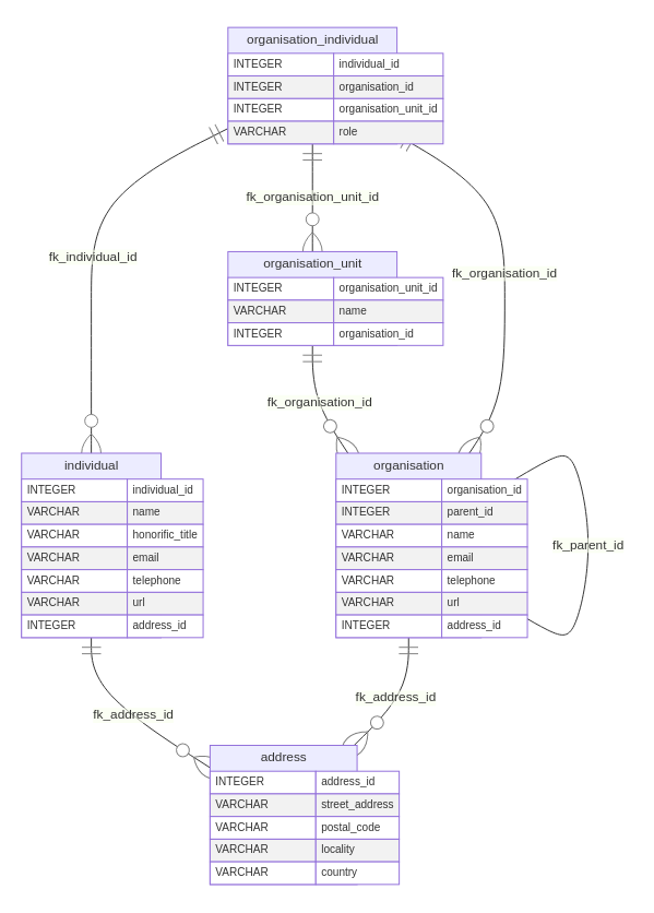
6.2.1 Overview
The current data model is primarily based on the vCard classes
Organisation, Individual and
Address with respective tables for each (Figure 7). An
organisation is typically a set of individuals that work together
towards a same goal (or set of goals), but its meaning can be taken more
broadly depending on the context. In most countries organisations are
legal entities. Semantically the relevance is in distinguishing the
collective from an individual. Organisations have a name and can be
contacted through an e-mail address or a telephone number. They also may
have a URL locating them in the digital space. Organisations can be set
up in a hierarchical fashion, through a parent-child relationship.
Organisations can also be sub-divided in various units
(organisation_unit table).
The individual is a person, usually subject to a set of legal rights
and obligations. The individual has a name and honorific title and can
be contacted by e-mail or telephone. An individual can also have a URL
to a web page of interest. Individuals can be part of an indefinite
number of organisations (through the
organisation_individual table). They may instead relate
directly to a particular unit inside an organisation.
The address table provides structure for physical postal
addresses of individuals and organisations. Currently the relations to
this table are one-to-many, allowing for various individuals to have the
same address. This is a somewhat permissive structure, following the
open nature of vCard, that may be made more restrictive if
necessary.
6.2.2 Encapsulation
The entities created for the meta-data model are stored in their own
database schema, named metadata. This limits the number of
tables in the main schema (named core) facilitating human
interaction with the database and its documentation. Foreign keys from
the core schema to the metadata schema provide
the appropriate relations between the two.
Not all database management systems (DBMS) implement the concept of schema laid out in the SQL standard. Some include the concept but do not provided standard interaction. Therefore this option for encapsulating the meta-data entities in their own schema limits the range of DBMS that can host this database.
6.3 Relations with ISO 28258 entities
With a meta-data data model established, relations with the ISO 28258 entities were devised, reflecting expectations on the field work conducted within Soils4Africa and similar projects. These relations identify the organisations and individuals responsible for data collection and/or asset storage. A simple matrix of relations was developed to aid discussion with domain experts (Table 1).
| Individual | Organisation | |
|---|---|---|
| Project | None | One or more |
| Plot | One or more | None |
| Surface | One or more | None |
| Profile | None | None |
| Element | None | None |
| Specimen | None | One |
| Results (Physio-Chemical) | One | None |
A project may involve one or more organisations responsible for
conducting a survey, or any other kind of soil investigation, including
one or more plots. Each plot is surveyed by one or more individuals that
in principle must be present at location. This resulted in the tables
project_organisation, plot_individual and
surface_individual. The individuals associated with a plot
are also responsible for all descriptive results gathered on the
profiles and profile elements surveyed within the plot.
Neither elements nor profiles refer to individuals or organisations.
These entities are part of the investigation conducted on the plot and
therefore associated to the respective individual. However, the
specimens surveyors collect are sent to a storage facility hosted by an
organisation that must be identified. It is also necessary to track
individuals responsible for physio-chemical measurements conducted in
laboratories. Hence a direct reference from this kind of result to the
individual table.
7 Operational aspects
7.1 Migrations
The database documented in this manuscript is developed with the migrations framework from the Graphile project 5. Migrations provide a versioning mechanism for the incremental development of a database. The tool facilitates rolling back and forth between different points in the development history, by applying or suppressing the SQL instructions that create the database structure.
Listing 5 provides a simple example on how to deploy the ISO 28258
database with graphile-migrate. First the repository is
cloned from the code forge, then the .env file must be
edited to point environmental variables to the correct database cluster.
Finally the environmental variables are loaded to the session and the
migrations are run.
Listing 5: Simple instruction set to deploy a new instance of the ISO 28258 database.
git clone git@git.wur.nl:isric/databases/iso28258.git

cd iso28258

vim .env

source .env

yarn graphile-migrate migrate
Further documentation on the use of graphile-migrate is
beyond the scope of this manuscript. The main project
README file includes basic instructions.
7.2 Integrating modifications to downstream databases
The database document here is likely to evolve in the future, simply
with the correction of bugs or the introduction of general requirements,
as is the case with the metadata schema. Any modifications
to the entities described in Section 3 through Section 6 must therefore
percolate to any downstream databases, i.e. those developed from this
template. This is best managed with migrate setup script, usually stored
in the downstream migrations/setup folder. Modifications to
the iso28258 repository can then be reflected in this
script. The steps to produce one are the following:
Apply the necessary modifications with a new migration in the
iso28258repository.Create a new tag in the
iso28258repository, marking a new release.Obtain a backup from the
iso28258repository with thepg_dumptool, marking the resulting file with the version (e.g._v1.1). This dump must include only thecoreandmetadataschemas, ignore ownership and add data asINSERTinstructions, as Listing 6 exemplifies.Replace the setup script in the
migrations/setupfolder of the downstream repository.Update the
.gmrcfile in the downstream repository to load the new script ("afterReset"section).Fully re-run migrations in the downstream database (
resetparameter).
Listing 6: Dumping relevant schemas from the iso28258 database as set-up for a derived database.
pg_dump iso28258 --inserts --no-owner -n core -n metadata > iso28258_v1.1.sql8 Future work
8.1 Uncertainties
The estimation and recording of measurement uncertainties has been a topic of active research at ISRIC. However, this aspect has so far been left outside soil ontology initiatives. The absence of uncertainty elements in O&M itself is a contributing factor to this state of affairs.
Measurement uncertainty is likely associated with the procedures employed. Particularly those used in the laboratory, but so too in field observations. Beyond those, spectral models also carry intrinsic estimate uncertainties that can be relevant to store.
In the data model, uncertainties are expected to be primarily associated with entities implementing Procedure-type classes of O&M. However, other aspects may also warrant this kind of information. Positioning uncertainty is an example. Results themselves may be subject to uncertainties too, for instance to convey particular conditions to field work. This area of soil ontology likely requires further refinement in requirements before it can be introduced to the data model.
8.2 Maintaining the downstream synchronicity to ISO 28258
Once a downstream data model starts being used effectively, storing actual results records, the integration procedure with the parent ISO data model, described in Section 7.2, becomes less evident. Some modifications may be straightforward to apply in the same fashion, e.g. adding a new, nullable column to an existing table. But others may imply modifications to existing records, that do not fit within the existing procedure.
Two approaches are possible to this issue. First is to devise an additional strategy to apply changes from the parent model without loss or corruption of data. This likely requires an additional backup and restore mechanism. The other approach is to simply let the two data models diverge. While not optimal, this latter approach is by far the cheapest, and if the parent model is not expected to evolve much further, it might not have much consequence.
Acknowledgment

|
This report is part of a project that has received funding from the European Union’s Horizon 2020 research and innovation programme under grant agreement No 862900. |